The Eastern Highland Rim - Part 2 - Geography

Table of Contents
- Definitions
- Karst
- Sandstone
- Karst Springs
- Pits
- Insurgences and Swallets
- Karst Windows
- Bangor Limestone / Hartselle Sandstone / Monteagle Limestone Contacts
- St. Louis Limestone / Warsaw Limestone Contact
- Fort Payne Chert / Chattanooga Shale Contact
Geography
Natural Arches
Caves
Sinkholes
Waterfalls
Regional Geology Presentation (2 hours)
Geography of the Eastern Highland Rim
Definitions
Contact - The contact between two rock units. This is used interchangeably with geologic contact.
Eastern Highland Rim - Mississippian age rocks underlying the Cumberland Plateau and adjacent areas.
Karst - Refers to a landscape, or landscape features that was created by water dissolving the bedrock. Examples are sinkholes and caves.
Rock Unit - A rock unit is a volume of rock of identifiable origin and relative age range. They are differentiated by a sudden change in rock type, or change in fossils. Many of these will be referred to by their proper names as used in Tennessee. Some minor differences across state lines do exist, but will not be covered here.
Natural arches are morphologically any holes that pass through rock large enough to be noteworthy. I personally differentiate arches as being large enough to get myself through, and windows being between that size and still large enough to fit my arm through. Any smaller and they aren't noteworthy.
Natural Arches
Natural arches are morphologically any holes that pass through rock large enough to be noteworthy. I personally differentiate arches as being large enough to get myself through, and windows being between that size and still large enough to fit my arm through. Any smaller and they aren't noteworthy.
Arches are different from caves, in that caves are larger and continue deep into the bedrock, where arches are primarily of interest and described on the surface at rock outcrops and along cliffs. When a stream or river flows under the arch, it is then called a natural bridge. Natural arches of the Eastern Highland Rim are differentiated into two distinct types, covered below.
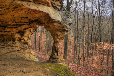
Sometimes, during the natural process of cave formation, erosion occurs in such a way that arches are created. In the example up and to the left, Medley Arch in Fall Creek Falls, was created because a large cave passage collapsed two entrances, and grew. Only a thin slice of Hartselle sandstone remains upon what was once the roof of the cave.
Bigalo Jingoist Hole, AKA Z Hole, pictured below and to the right was the result of a meander in the nearby river cutting into the bedrock. Later the river valley lowered, leaving a arch up off the valley floor in a cliff. Large caves have been formed as that river wound through the valley, occasionally changing course to run through the dissolving limestone on the flanks of the rim. As the valley lowered, stream channels were abandoned and became paleo-trunks in these large caves.


Pictured below are some of the finest examples of natural sandstone arches in the state, and they are tightly clustered in a single, very accessible area. They also represent one of the few sandstone arches on the Eastern Highland Rim. In contrast, the Cumberland Plateau just elevationally above this physiographic province has the second largest concentration of arches in North America (just behind the the Grand Staircases).
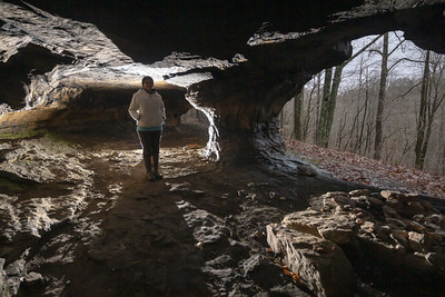
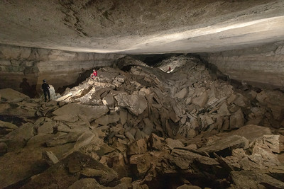
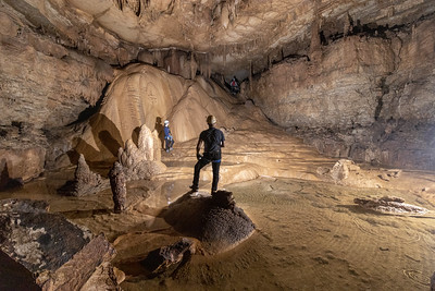
Few places have the density of caves and caverns quite like those of the Eastern Highland Rim (Mammoth Cave area, and the Ozark Mountains being noteworthy exceptions). Below is a generalized map of the Eastern Highland Rim overlaid with cave density.

In caving we refer to the area at the intersection of Tennessee, Alabama, and Georgia as TAG (an anacronym for the state names). It's largely understood that we have spectacular caves. Most of these caves are formed in Mississippian limestones associated with or within the Eastern Highland Rim.

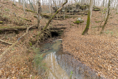
Underground water has to go somewhere. In karst landscapes, large rivers suddenly emerging from the ground are fairly common. Many of these large springs have associated caves. More intriguing are the large springs with no known cave. A caver's fantasy is moving a few rocks, squirming through a hole and being the first human into a large cave system.
These places have a few names scientists and cavers use, like resurgence, spring, or reappearing stream.
Pits, by definition of the Tennessee Cave Survey are vertical caves that cannot be free climbed safely. Often, they "bell outward" where the entrance is overhung on all sides and as one rappels downwards, the dimensions get larger.
Pits are formed by the same methods of dissolution that create caves, except vertical dissolution will cut the limestone in particular ways. Flutes, domes, and waterfalls are often associated with pits.


In a general sense, a sinkhole indicates the current or prior presence of a subsurface fluid-filled void (whether water or air or both as is often the case in Tennessee). The Earth is a dynamic place, and stream systems are no exception. Many of our streams run underground in the area of the middle elevations of the Eastern Highland Rim (See St. Louis and Warsaw limestones from part one of this article). Those underground streams affect the land above them and pocket them with cave entrances and sinkholes which capture and transport water.


An insurgence is where water disappears into the ground. A swallet is often the lowest place in a sinkhole that also takes water. The words are similar and can often be interchanged. Insurgence is more often used for perennial streams as opposed to ephemeral streams.


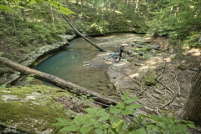
Karst windows are "windows" into a cave. A karst window has an upstream and downstream section (even if the stream is long gone) where passage is visible on both sides. These form when a cave passage collapses and exposes a portion of the cave to the surface. Often there will be an upstream cave and a downstream cave connected by a stream.
![Karst Window, White County, Tennessee [Map]](https://live.staticflickr.com/65535/50956422267_8e1631dea8_c.jpg)
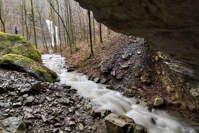
Something about a waterfall really captures our soul, doesn't it? We love to sit beside them and contemplate. Maybe it's the roar of the falls drowning out nearby conversations and our worries? Maybe it's a place that prehistoric man used to catch fish and we still posses some epigenetic memory of it? Maybe it's aesthetically pleasing because water is the source of all life on Earth? Whatever it is, here are some of the patterns relating to the local geology that drive waterfall formation on the Eastern Highland Rim.
There is a special configuration of karst which is both a karst window and a waterfall. This happens in a few places along the Eastern Highland Rim, always at the same geologic contacts of Bangor Limestone (representing the upper cave passage), the Hartselle Sandstone (the floor of the cave, and the lip of the waterfall), and the Monteagle Limestone (the waterfall face and the cave which the water sinks into).
These waterfalls are among the most spectacular things that Tennessee can offer outdoor enthusiasts. Virgin Falls SNA has three features (Virgin Falls, Sheep Falls, and Big Laurel Falls) which are along this set of geologic contacts. Just over the ridge, there is Lost Creek Falls, Spring Drop Falls, and Rylander Falls all of which exhibit the same geomorphology.


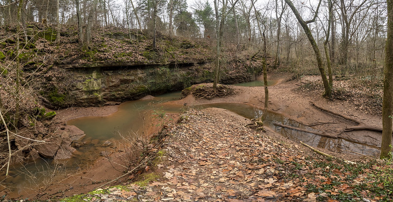
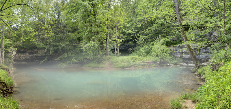
A number of smaller waterfalls can be found at the contact of the St. Louis and Warsaw Limestone. There appear the be localized chert and shale beds between the two layers causing the waterfalls to occur. In some places the contact is underground, in others is is exposed on the surface, as shown above. It always emerges from a karst spring (where a cave is sometimes accessible), flows a short distance, and makes its drop down into the Warsaw.


This part of Tennessee has some of the best waterfalls. Some of the best are at the geologic contact of the Fort Payne Chert and Chattanooga Shale. Where a stream crosses that contact, one tends to get waterfalls.
This configuration was so noticeable, I created a computer model using GIS (Geographic Information Systems) to see where waterfalls were that weren't on maps. It produced so many possibilities, I had to constrain the model by the criteria of the area of the upstream watershed, prioritizing those with the highest area. My thought was, more area, more water to go over a waterfall!
I validated this model in the field once, at Sink Creek in Dekalb County, pictured above. It was a cool feeling to know there would be an undocumented waterfall at that location before I arrived. Interestingly, there are remnants of an old mill site there. I was certainly not the first human to stumble upon this beautiful natural feature.
Fine Print:
As you read through this, please understand that the classifications of landforms that I use are somewhat subjective. Fro example, some features can be called a sinkhole, a karst window, and a waterfall; all insurgences are sinkholes; etc.
I've done my best to organize information about the landforms in a specific way so as to make it easier to understand. The information that I am conveying here is based on years of field experience, mostly out looking for caves, or looking at interesting road cuts. I invite professional geologists to comment and critique me. I am certain that there may exist some mistake. In other words, if you're building a multi-million dollar facility, and you're using this blog post as a source for your work, you'll want to double-check me. I have done my best to convey factual information here. Enjoy. :)
Karst Arches
Sometimes, during the natural process of cave formation, erosion occurs in such a way that arches are created. In the example up and to the left, Medley Arch in Fall Creek Falls, was created because a large cave passage collapsed two entrances, and grew. Only a thin slice of Hartselle sandstone remains upon what was once the roof of the cave.
Bigalo Jingoist Hole, AKA Z Hole, pictured below and to the right was the result of a meander in the nearby river cutting into the bedrock. Later the river valley lowered, leaving a arch up off the valley floor in a cliff. Large caves have been formed as that river wound through the valley, occasionally changing course to run through the dissolving limestone on the flanks of the rim. As the valley lowered, stream channels were abandoned and became paleo-trunks in these large caves.
Sandstone Arches
Pictured below are some of the finest examples of natural sandstone arches in the state, and they are tightly clustered in a single, very accessible area. They also represent one of the few sandstone arches on the Eastern Highland Rim. In contrast, the Cumberland Plateau just elevationally above this physiographic province has the second largest concentration of arches in North America (just behind the the Grand Staircases).
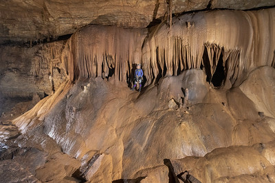
Caves
Few places have the density of caves and caverns quite like those of the Eastern Highland Rim (Mammoth Cave area, and the Ozark Mountains being noteworthy exceptions). Below is a generalized map of the Eastern Highland Rim overlaid with cave density.
In caving we refer to the area at the intersection of Tennessee, Alabama, and Georgia as TAG (an anacronym for the state names). It's largely understood that we have spectacular caves. Most of these caves are formed in Mississippian limestones associated with or within the Eastern Highland Rim.
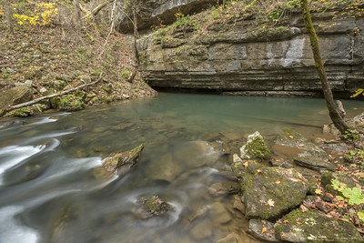
Karst Springs
Underground water has to go somewhere. In karst landscapes, large rivers suddenly emerging from the ground are fairly common. Many of these large springs have associated caves. More intriguing are the large springs with no known cave. A caver's fantasy is moving a few rocks, squirming through a hole and being the first human into a large cave system.
These places have a few names scientists and cavers use, like resurgence, spring, or reappearing stream.
Pits
Pits, by definition of the Tennessee Cave Survey are vertical caves that cannot be free climbed safely. Often, they "bell outward" where the entrance is overhung on all sides and as one rappels downwards, the dimensions get larger.
Pits are formed by the same methods of dissolution that create caves, except vertical dissolution will cut the limestone in particular ways. Flutes, domes, and waterfalls are often associated with pits.
Sinkholes
In a general sense, a sinkhole indicates the current or prior presence of a subsurface fluid-filled void (whether water or air or both as is often the case in Tennessee). The Earth is a dynamic place, and stream systems are no exception. Many of our streams run underground in the area of the middle elevations of the Eastern Highland Rim (See St. Louis and Warsaw limestones from part one of this article). Those underground streams affect the land above them and pocket them with cave entrances and sinkholes which capture and transport water.
Insurgences and Swallets
An insurgence is where water disappears into the ground. A swallet is often the lowest place in a sinkhole that also takes water. The words are similar and can often be interchanged. Insurgence is more often used for perennial streams as opposed to ephemeral streams.
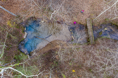
Karst Windows
Karst windows are "windows" into a cave. A karst window has an upstream and downstream section (even if the stream is long gone) where passage is visible on both sides. These form when a cave passage collapses and exposes a portion of the cave to the surface. Often there will be an upstream cave and a downstream cave connected by a stream.
Waterfalls
Something about a waterfall really captures our soul, doesn't it? We love to sit beside them and contemplate. Maybe it's the roar of the falls drowning out nearby conversations and our worries? Maybe it's a place that prehistoric man used to catch fish and we still posses some epigenetic memory of it? Maybe it's aesthetically pleasing because water is the source of all life on Earth? Whatever it is, here are some of the patterns relating to the local geology that drive waterfall formation on the Eastern Highland Rim.
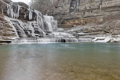
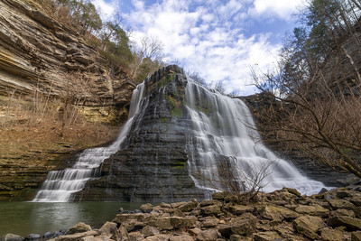
Bangor Limestone / Hartselle Sandstone / Monteagle Limestone Contacts
There is a special configuration of karst which is both a karst window and a waterfall. This happens in a few places along the Eastern Highland Rim, always at the same geologic contacts of Bangor Limestone (representing the upper cave passage), the Hartselle Sandstone (the floor of the cave, and the lip of the waterfall), and the Monteagle Limestone (the waterfall face and the cave which the water sinks into).
These waterfalls are among the most spectacular things that Tennessee can offer outdoor enthusiasts. Virgin Falls SNA has three features (Virgin Falls, Sheep Falls, and Big Laurel Falls) which are along this set of geologic contacts. Just over the ridge, there is Lost Creek Falls, Spring Drop Falls, and Rylander Falls all of which exhibit the same geomorphology.
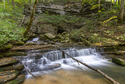
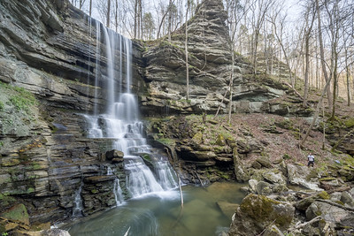
St. Louis Limestone / Warsaw Limestone Contact
A number of smaller waterfalls can be found at the contact of the St. Louis and Warsaw Limestone. There appear the be localized chert and shale beds between the two layers causing the waterfalls to occur. In some places the contact is underground, in others is is exposed on the surface, as shown above. It always emerges from a karst spring (where a cave is sometimes accessible), flows a short distance, and makes its drop down into the Warsaw.
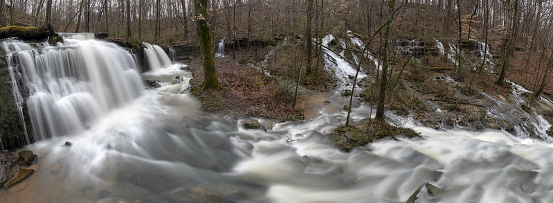
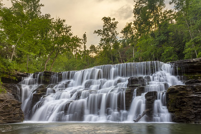
Fort Payne Chert and Chattanooga Shale Contact
This part of Tennessee has some of the best waterfalls. Some of the best are at the geologic contact of the Fort Payne Chert and Chattanooga Shale. Where a stream crosses that contact, one tends to get waterfalls.
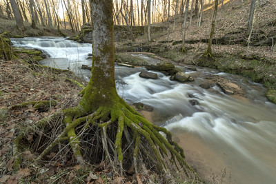
This configuration was so noticeable, I created a computer model using GIS (Geographic Information Systems) to see where waterfalls were that weren't on maps. It produced so many possibilities, I had to constrain the model by the criteria of the area of the upstream watershed, prioritizing those with the highest area. My thought was, more area, more water to go over a waterfall!
I validated this model in the field once, at Sink Creek in Dekalb County, pictured above. It was a cool feeling to know there would be an undocumented waterfall at that location before I arrived. Interestingly, there are remnants of an old mill site there. I was certainly not the first human to stumble upon this beautiful natural feature.
Fine Print:
As you read through this, please understand that the classifications of landforms that I use are somewhat subjective. Fro example, some features can be called a sinkhole, a karst window, and a waterfall; all insurgences are sinkholes; etc.
I've done my best to organize information about the landforms in a specific way so as to make it easier to understand. The information that I am conveying here is based on years of field experience, mostly out looking for caves, or looking at interesting road cuts. I invite professional geologists to comment and critique me. I am certain that there may exist some mistake. In other words, if you're building a multi-million dollar facility, and you're using this blog post as a source for your work, you'll want to double-check me. I have done my best to convey factual information here. Enjoy. :)


Comments