Kentucky Cave Distribution Map, 2017
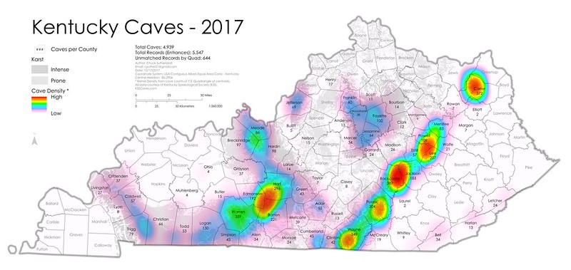 This map represents the generalized distribution of cave entrances in Kentucky based on data from the 2017 release of the Kentucky Speleological Society (the data is generalized by 7.5 minute quadrangle). A few easily observable patterns exist and are worth description.
The line of density which extends northeast / southwest shows the margin of the Cumberland Plateau where Mississippian aged limestones outcrop.
The ring of density west of there is the Inner Bluegrass Karst region where erosion of the Cincinnati Arch has exposed Middle Ordovician carbonates. The dense area centered at Edmonson, Hart, and Barren counties represents the Mammoth cave region and the caves of the Pennyroyal plateau. Mammoth Cave is still the world's longest cave, with a newly announced length of 412 miles.
The most cave entrance dense quadrangle recorded is Johnetta in Rockcastle County, but this is likely only sampling bias. This bias could occur because caves are easier to get to, or more likely because cavers are active in that area. Another possible example of sampling bias is in Carter County, which has been the focus of cavers and of much documentation. This may account for its high totals versus other limestone rich areas. To this end, this map serves as wonderful tool to generate the next areas of exploration, as we see several limestone areas that seem to have few caves.
Overall, Kentucky has 4,939 documented caves, and 5,547 documented cave entrances (some caves have more than one entrance). Data from the Kentucky Speleological Survey (KSS) comes from cavers and scientists, and has been collected and compiled since 2000.
Thanks Howard Kalnitz for the assist on this write up!


Comments