Lidar Map of Sparta, Tennessee
I wanted to make a map of my hometown of Sparta, Tennessee using the newly available lidar from the State of Tennessee. Compared with previous maps, like the USGS 1:24,000 topographic map, the new lidar data is approximately 700 times more accurate. You'll see what I mean below.
After I produced it there were just too many odd little things that were worth explaining. The first half of odd things are natural processes on the Earth that produce a specific form, or in more scientific terms, the features are of a geomorphic nature. The remainder of forms I want to share with you are human formed, or anthropogenic.
First, let's look at the map. Your web browser likely won't let you see it in full hi-res glory (the image is 4'x3' at 300 DPI, it's big at 77 megabytes), so here is a hard link to the hi-res image.
 Below is the stuff I thought was interesting. Feel free to follow along if you've downloaded the hi-res map.
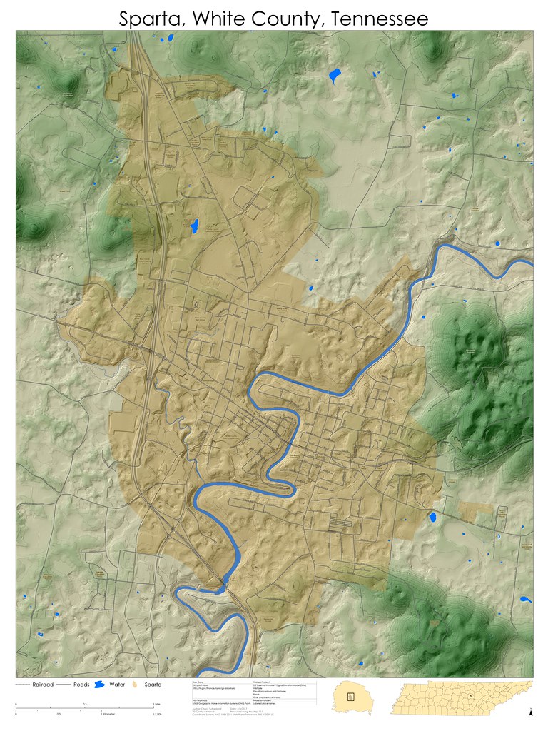
Monteagle Limestone Boulder
Field
 In the north-west of the map, here are two small green
colored mountains that rise around 300’ above the surrounding landscape. Look
closely at the hills and you will see that they are quite rough. If you’re
looking at this in real life, you’ll see a bunch of grey rocks jutting up
through a thin layer of soil. This landscape should be familiar to many locals,
but it’s unlikely that most have considered why it is this way.
In the north-west of the map, here are two small green
colored mountains that rise around 300’ above the surrounding landscape. Look
closely at the hills and you will see that they are quite rough. If you’re
looking at this in real life, you’ll see a bunch of grey rocks jutting up
through a thin layer of soil. This landscape should be familiar to many locals,
but it’s unlikely that most have considered why it is this way.
The Monteagle limestone is our most prolific producer of
caves, with 34 percent of documented caves in Tennessee being formed entirely
or at least partly within this strata (TCS 2016). That’s the same reason the
landscape is boulder-strewn with little to no soil. The caves exist because the
rock dissolves and leaves little insoluble material behind. What remains is a
thin soil that doesn’t completely cover the bedrock. This is exposed in many
places across White County. I have taken to calling those areas Monteagle
boulder field. Also noteworthy, but not surprising, is that there are few
structures on this type of landscape.
Monteagle Limestone Sinkholes
 On the eastern border of the map, at the half-way point of
north and south, one can see the foothills of Dibrell Mountain, where Highway
70 winds its way up to the Cumberland Plateau. In those foothills there are
large sinkholes that look like pockmarks on this map. Contrast those with the
St. Louis sinkholes mentioned below. Moneagle sinkholes are more circular, and
in this particular location are around 60’ deep. Some of the larger sinkholes
are not exactly circular, which is likely result of two or more sinkholes
combining.
On the eastern border of the map, at the half-way point of
north and south, one can see the foothills of Dibrell Mountain, where Highway
70 winds its way up to the Cumberland Plateau. In those foothills there are
large sinkholes that look like pockmarks on this map. Contrast those with the
St. Louis sinkholes mentioned below. Moneagle sinkholes are more circular, and
in this particular location are around 60’ deep. Some of the larger sinkholes
are not exactly circular, which is likely result of two or more sinkholes
combining.
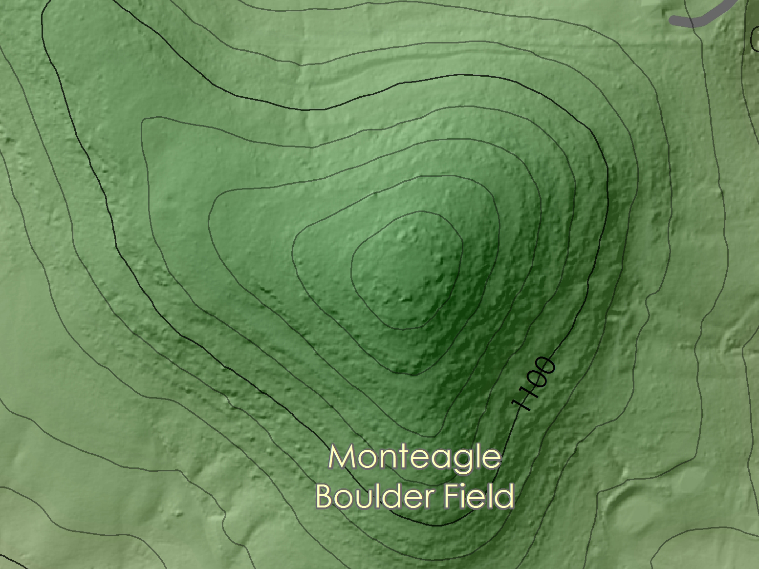
St. Louis Limestone Sinkholes
and the Sinkhole Plain
East of the center of the map (and in many other places), a
line of shallow sinkholes runs north to south down to the Calfkiller River.
Comparing these sinkholes with those of the Monteagle limestone a few things
should be apparent. They tend to be less circular, some have visible drainage
channels within them, and many of them have distinct swallets (looks like a
steeper sinkhole inside the sinkhole). They rarely occur isolated and are more
often found in large irregularly connected networks. The networks are remnants
of collapsed stream caves. It also may be evident that there are few smaller
surface streams on this map. This is due largely to the St. Louis limestone’s
high solubility forcing streams underground.
Karst Spring
 If the streams are underground, then they must surface at
some point. By following Town Spring to its source you can find this location
on the map. Karst springs are places where the rivers emerge. Often what they
look like is a low shelf of boulders with water coming from in between them. As
a caver, I would love to be able to get into all the caves behind them, but few
are accessible.
If the streams are underground, then they must surface at
some point. By following Town Spring to its source you can find this location
on the map. Karst springs are places where the rivers emerge. Often what they
look like is a low shelf of boulders with water coming from in between them. As
a caver, I would love to be able to get into all the caves behind them, but few
are accessible.
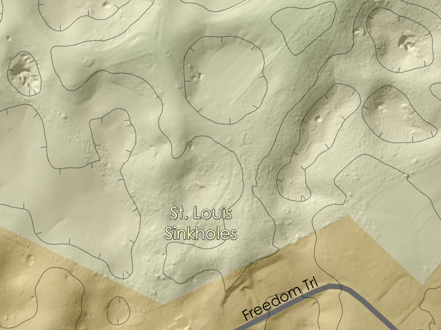
Row Crop Agriculture
vs Pasture and Hay
 You know where Walmart is (that’s not a question). Look west
from there on the other side of County Highway 1161. There you’ll find a
distorted rectangular property with an interesting pattern on the soil. Those
are overlapping rows, possibly where the farmer dug rows at a different
direction than a previous year. Several other examples of rows can be seen if
one looks closely.
You know where Walmart is (that’s not a question). Look west
from there on the other side of County Highway 1161. There you’ll find a
distorted rectangular property with an interesting pattern on the soil. Those
are overlapping rows, possibly where the farmer dug rows at a different
direction than a previous year. Several other examples of rows can be seen if
one looks closely.
Thompson Weiman
Quarry
 Many Spartans are familiar with this large abandoned
limestone quarry, but if you need help finding it on the map, look to where
Highway 70 is on the east side of the map and go a little north.
Many Spartans are familiar with this large abandoned
limestone quarry, but if you need help finding it on the map, look to where
Highway 70 is on the east side of the map and go a little north.
The entrance to the quarry is quite obvious on the map. For
those who have been there, they will recognize the towering cliffs. For those
who haven’t been there, the quarry runs underground some distance.
Abandoned Railroad
Following the obvious linear railroad bed south-west from
the Thompson Weiman Quarry, one can follow what was once the route of the
railroad. The line traces Nent Flatt St, turns southward at Baker St, and
almost disappears until the south side of Gaines St. The railroad would have
started westward, crossing South Young St and the Calfkiller River (using the
same bridge as the current pedestrian walkway), and heads north towards the
White County Sheriff’s Department where it would have joined a spur rail to the
north which is, surprise, on Depot St. The modern rail line begins at roughly
the intersection of these two historic lines.
Waste Water Treatment
Plant
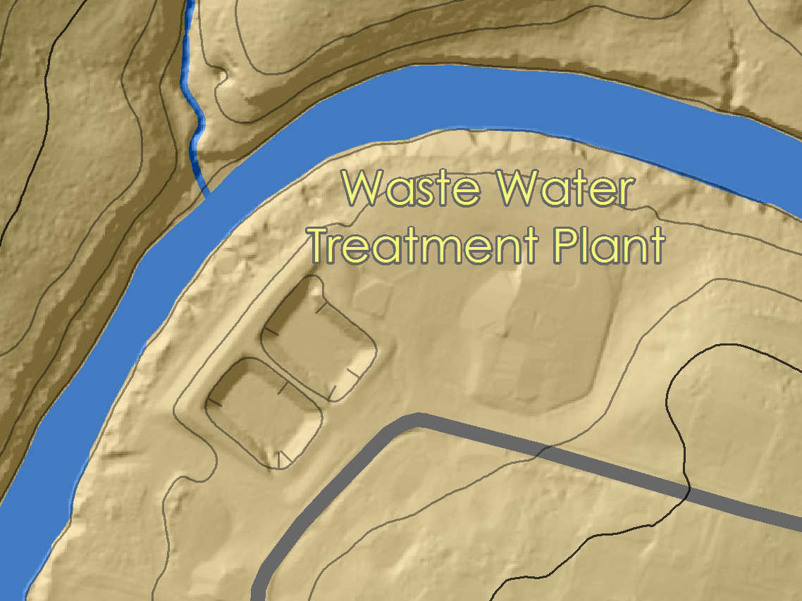 Almost dead center of this map is where our sewer waste goes
to be treated. Two large pools can be seen.
Almost dead center of this map is where our sewer waste goes
to be treated. Two large pools can be seen.
Low head dam on the
Calfkiller River
Downstream from the waste water plant, just before where
Calfkiller River goes under Highway 111, there is a low head dam. Many of us
have seen this as we have driven past. Have you ever wondered wh it’s there?
Read on.
T & A Hydroelectric
Plant
 Following the north shore downstream of the previously
mentioned low head dam, there is a linear feature which runs parallel to the
river. This is a causeway along which water from the river was once diverted to
run a powerhouse. The causeway, and much of the poured cement structure are
still in place, as well as the powerhouse itself.
Following the north shore downstream of the previously
mentioned low head dam, there is a linear feature which runs parallel to the
river. This is a causeway along which water from the river was once diverted to
run a powerhouse. The causeway, and much of the poured cement structure are
still in place, as well as the powerhouse itself.
Clarks Mill
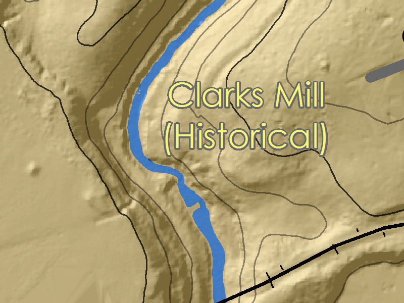 On Town Creek, just north of where the railroad crosses
overhead, I found curious evidence of a large dam that failed. Until the
creation of this map and the integration of the GNIS dataset, I had not been
able to identify the structure. Looking at this map, one can now only see two
lines perpendicular to the stream which represent parts of the dam structure of
the mill.
On Town Creek, just north of where the railroad crosses
overhead, I found curious evidence of a large dam that failed. Until the
creation of this map and the integration of the GNIS dataset, I had not been
able to identify the structure. Looking at this map, one can now only see two
lines perpendicular to the stream which represent parts of the dam structure of
the mill.
Drive in Theater
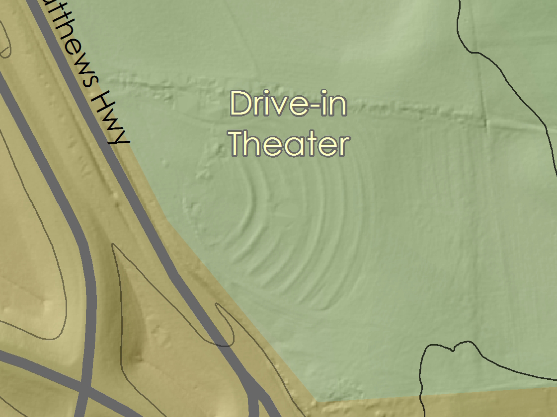 Just outside the city limits of Sparta, on the north side
and east of Highway 111, one can see moved earth in a radial pattern. If you’ve
enjoyed watching movies at the Sparta Drive-In, then you’ll immediately
recognize that those are the low rises for each successive row for cars to park
in.
Just outside the city limits of Sparta, on the north side
and east of Highway 111, one can see moved earth in a radial pattern. If you’ve
enjoyed watching movies at the Sparta Drive-In, then you’ll immediately
recognize that those are the low rises for each successive row for cars to park
in.
After I produced it there were just too many odd little things that were worth explaining. The first half of odd things are natural processes on the Earth that produce a specific form, or in more scientific terms, the features are of a geomorphic nature. The remainder of forms I want to share with you are human formed, or anthropogenic.
First, let's look at the map. Your web browser likely won't let you see it in full hi-res glory (the image is 4'x3' at 300 DPI, it's big at 77 megabytes), so here is a hard link to the hi-res image.
Monteagle Limestone Boulder Field
In the north-west of the map, here are two small green
colored mountains that rise around 300’ above the surrounding landscape. Look
closely at the hills and you will see that they are quite rough. If you’re
looking at this in real life, you’ll see a bunch of grey rocks jutting up
through a thin layer of soil. This landscape should be familiar to many locals,
but it’s unlikely that most have considered why it is this way.
On the eastern border of the map, at the half-way point of
north and south, one can see the foothills of Dibrell Mountain, where Highway
70 winds its way up to the Cumberland Plateau. In those foothills there are
large sinkholes that look like pockmarks on this map. Contrast those with the
St. Louis sinkholes mentioned below. Moneagle sinkholes are more circular, and
in this particular location are around 60’ deep. Some of the larger sinkholes
are not exactly circular, which is likely result of two or more sinkholes
combining.
East of the center of the map (and in many other places), a
line of shallow sinkholes runs north to south down to the Calfkiller River.
Comparing these sinkholes with those of the Monteagle limestone a few things
should be apparent. They tend to be less circular, some have visible drainage
channels within them, and many of them have distinct swallets (looks like a
steeper sinkhole inside the sinkhole). They rarely occur isolated and are more
often found in large irregularly connected networks. The networks are remnants
of collapsed stream caves. It also may be evident that there are few smaller
surface streams on this map. This is due largely to the St. Louis limestone’s
high solubility forcing streams underground.
If the streams are underground, then they must surface at
some point. By following Town Spring to its source you can find this location
on the map. Karst springs are places where the rivers emerge. Often what they
look like is a low shelf of boulders with water coming from in between them. As
a caver, I would love to be able to get into all the caves behind them, but few
are accessible. Row Crop Agriculture vs Pasture and Hay
You know where Walmart is (that’s not a question). Look west
from there on the other side of County Highway 1161. There you’ll find a
distorted rectangular property with an interesting pattern on the soil. Those
are overlapping rows, possibly where the farmer dug rows at a different
direction than a previous year. Several other examples of rows can be seen if
one looks closely.Thompson Weiman Quarry
Many Spartans are familiar with this large abandoned
limestone quarry, but if you need help finding it on the map, look to where
Highway 70 is on the east side of the map and go a little north.
Almost dead center of this map is where our sewer waste goes
to be treated. Two large pools can be seen.
Following the north shore downstream of the previously
mentioned low head dam, there is a linear feature which runs parallel to the
river. This is a causeway along which water from the river was once diverted to
run a powerhouse. The causeway, and much of the poured cement structure are
still in place, as well as the powerhouse itself. Clarks Mill
On Town Creek, just north of where the railroad crosses
overhead, I found curious evidence of a large dam that failed. Until the
creation of this map and the integration of the GNIS dataset, I had not been
able to identify the structure. Looking at this map, one can now only see two
lines perpendicular to the stream which represent parts of the dam structure of
the mill. Drive in Theater
Just outside the city limits of Sparta, on the north side
and east of Highway 111, one can see moved earth in a radial pattern. If you’ve
enjoyed watching movies at the Sparta Drive-In, then you’ll immediately
recognize that those are the low rises for each successive row for cars to park
in.


Comments
Just found this on-line. Nice work my friend.
Allen R. Coggins
Mike S