Loading Data into Locus Pro
Every TAG caver knows that Locus Pro is the best GPS program for you mobile device (sorry iPhone users it's only for Android). Locus Pro easily handles the ten thousand plus data points for the Tennessee Cave Survey's dataset of cave entrances, and can simultaneously display several other hefty datasets atop it. I'm running a Pixel 3 and it runs quite smoothly.

So you've got a dataset, maybe it's the new TCS distribution, or maybe it's some other KML or GPX file and you want to load it to Locus Pro. Here's how you do that. We start with the screen above. My layout may be different than yours, so if it's unfamiliar don't sweat it. We're looking for the Data menu. Above I've circled its icon in red. You can also get to this menu by pressing the three bars in the upper left and going to Points.

Your Data menu should look something like the above, perhaps without all the lines and the weird mosaic blur (don't ask).
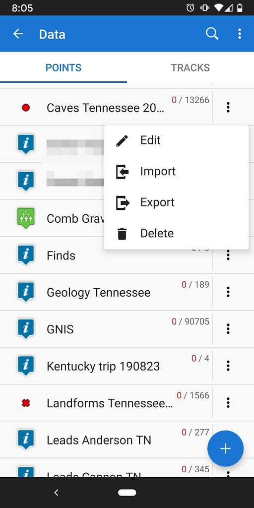
I can see an already existing TCS dataset. Let's see what year it is by hitting the three vertical dots and selecting edit.

This is 2018 cave data. We can just delete this since the dataset we're about to load is new and improved. Hit cancel and return to the previous menu.

Hit the three vertical dots next to the folder and choose delete.

Let's load our data now. From the Data menu hit the blue plus sign in the bottom right.

Choose Import.

Wherever your data is (I don't know, don't ask me!), navigate to it. Mine is in a folder on my Google Drive which I have linked to Locus Pro. I've found the 2019 TCS KMZ file and I will select it.

It's asking you where you want this data to go. I like to put different data into different folders. This lets me toggle off and on the data that I need, when I need it. This keeps my map free of unnecessary clutter, and keeps my data organized. I am going to select Add New Folder.

Above are the settings I use for import.

This step is super important for TCS data users. Be sure to check Apply to all and hit ignore. This will allow multiple entries to be loaded with the same name. In other words, Indian Cave won't be overwritten as each county is loaded leaving you with only the last entry.
As a final step I would suggest you update your icons so your symbology doesn't clash on your maps. Hope this worked alright for you!
So you've got a dataset, maybe it's the new TCS distribution, or maybe it's some other KML or GPX file and you want to load it to Locus Pro. Here's how you do that. We start with the screen above. My layout may be different than yours, so if it's unfamiliar don't sweat it. We're looking for the Data menu. Above I've circled its icon in red. You can also get to this menu by pressing the three bars in the upper left and going to Points.
Your Data menu should look something like the above, perhaps without all the lines and the weird mosaic blur (don't ask).
I can see an already existing TCS dataset. Let's see what year it is by hitting the three vertical dots and selecting edit.
This is 2018 cave data. We can just delete this since the dataset we're about to load is new and improved. Hit cancel and return to the previous menu.
Hit the three vertical dots next to the folder and choose delete.
Let's load our data now. From the Data menu hit the blue plus sign in the bottom right.
Choose Import.
Wherever your data is (I don't know, don't ask me!), navigate to it. Mine is in a folder on my Google Drive which I have linked to Locus Pro. I've found the 2019 TCS KMZ file and I will select it.
It's asking you where you want this data to go. I like to put different data into different folders. This lets me toggle off and on the data that I need, when I need it. This keeps my map free of unnecessary clutter, and keeps my data organized. I am going to select Add New Folder.
Above are the settings I use for import.
This step is super important for TCS data users. Be sure to check Apply to all and hit ignore. This will allow multiple entries to be loaded with the same name. In other words, Indian Cave won't be overwritten as each county is loaded leaving you with only the last entry.
As a final step I would suggest you update your icons so your symbology doesn't clash on your maps. Hope this worked alright for you!


Comments