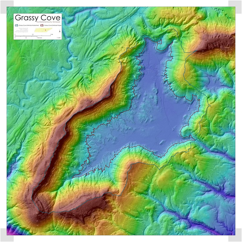
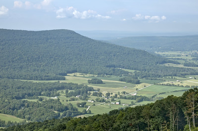
Tennessee has perhaps millions of sinkholes, most of which are very small features. Based on data analysis from a 2013 sinkhole study (Dunigan/Sutherland 2013) I have listed here some of the largest features by dimension in the state. Below you'll find an interactive map, and a table with this information, and more. Largest Sinkholes by Area
Largest Sinkholes by Depth
Largest Sinkholes by Volume
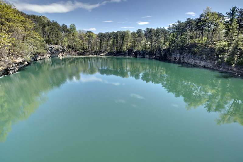
Excluded from these lists is Montlake in Hamilton County. It may fit on the volume or depth list, but I cannot easily get at that information since it is flooded. It is a truly spectacular feature. More about Montlake here. |
![]() ![]() ![]() ![]() ![]() |
Name | Coordinates (WGS84) | Area (Acres) | Depth (Ft) | Volume (ft^3) | Perimeter (ft) | Compactness | Thickness | MinElev | MaxElev |
Big Sink | 36.039613,-85.390357 | 164 | 260.43 | 33,513,671.59 | 13,376.46 | 1.37 | 0.5 | 1,427.13 | 1,687.23 |
Wolf Cove | 35.049637,-86.016843 | 121.15 | 242.06 | 19,228,967.68 | 16,139.71 | 2.21 | 0.25 | 962.68 | 1,204.42 |
Icy Cove | 36.058645,-85.293733 | 490.37 | 205.98 | 91,825,237.61 | 36,889.13 | 3.51 | 0.2 | 1,371.70 | 1,577.35 |
Whiteoak Sink | 35.635743,-83.749339 | 172.17 | 199.1 | 16,431,943.54 | 26,970.98 | 4.34 | 0.13 | 1,609.17 | 1,807.94 |
Unnamed sink* | 35.546072,-85.62248 | 12.91 | 182.04 | 998,910.68 | 4,379.16 | 1.97 | 0.37 | 1,637.70 | 1,819.42 |
Big Sink | 36.424762,-83.735956 | 95.26 | 164.66 | 10,775,783.37 | 19,480.25 | 4.47 | 0.14 | 1,162.10 | 1,326.43 |
Dykes Mountain | 35.517246,-85.65071 | 11.55 | 155.8 | 1,159,045.24 | 3,539.36 | 1.86 | 0.5 | 1,590.14 | 1,745.62 |
Buel Hall sink* | 36.453074,-85.336649 | 26.39 | 152.19 | 2,544,769.82 | 6,238.58 | 1.98 | 0.37 | 1,192.94 | 1,344.80 |
Round Cov | 36.074993,-85.354436 | 199.5 | 149.9 | 26,127,688.00 | 18,295.00 | 1.86 | 0.33 | 1,373.66 | 1,523.23 |
Big Sink | 35.586443,-85.672679 | 309.66 | 142.02 | 34,058,508.79 | 32,574.10 | 2.15 | 0.16 | 1,095.85 | 1,237.54 |
Turkey Cot Cove | 35.75857,-85.419588 | 110.81 | 141.37 | 10,977,717.85 | 15,116.03 | 2.1 | 0.27 | 1,314.30 | 1,455.34 |
Grassy Cove | 35.837423,-84.927752 | 3362.73 | 140 | 406,196,714.93 | 127,683.48 | 3.44 | 0.11 | 1,528.00 | 1,667.00 |
Little Cove | 35.850228,-84.892025 | 213.52 | 130 | 22,732,107.00 | 24,168.90 | 3.55 | 0.2 | 1,555.00 | 1,684.00 |
Pass Cove | 35.979505,-85.359774 | 234.33 | 118.08 | 16,824,388.71 | 37,909.46 | 2.68 | 0.09 | 1,107.66 | 1,225.41 |
The Big Sink | 35.137725,-85.906803 | 509.59 | 110.86 | 42,673,448.59 | 54,476.67 | 4.99 | 0.09 | 946.28 | 1,056.82 |
Sinking Cane Hollow | 36.200275,-85.269992 | 556.85 | 106.6 | 31,979,726.48 | 92,733.15 | 7.83 | 0.04 | 1,135.86 | 1,242.14 |
Sinking Creek | 36.333643,-82.300053 | 296.67 | 104.3 | 13,824,354.12 | 61,606.46 | 8.89 | 0.04 | 1,451.07 | 1,555.05 |
Round Cove** | 35.013707,-85.993681 | 215.97 | 103.98 | 15,863,366.27 | 32,579.55 | 4.73 | 0.11 | 912.5 | 1,016.14 |
Walker Hollow | 36.176813,-85.298605 | 132.69 | 99.38 | 8,145,574.86 | 24,413.11 | 6.22 | 0.12 | 1,249.02 | 1,348.08 |
Sinking Cove | 35.03797,-85.973261 | 1114.87 | 93.81 | 46,324,229.60 | 99,477.60 | 7.29 | 0.06 | 783.59 | 877.07 |
Dry Shave | 35.52793,-85.722465 | 204.09 | 88.89 | 12,605,837.73 | 34,374.41 | 3.34 | 0.09 | 1,124.06 | 1,212.62 |
Dog Cove | 35.870705,-85.358425 | 853.2 | 82 | 42,919,711.15 | 106,529.88 | 5.96 | 0.04 | 1,231.97 | 1,313.64 |
Crabtree Cove** | 35.02261,-86.06261 | 155.5 | 77.74 | 9,101,534.76 | 29,759.92 | 7.25 | 0.1 | 1,230.33 | 1,307.74 |
Board Valley | 36.041696,-85.375447 | 508.3 | 77.08 | 20,588,337.32 | 78,039.01 | 7.2 | 0.05 | 1,229.02 | 1,305.77 |
Unnamed sink* | 36.518118,-87.454714 | 370.86 | 62.32 | 12,164,077.88 | 37,621.46 | 2.38 | 0.14 | 485.11 | 547.1 |
Ebenezer sink* | 35.901836,-84.073098 | 546.41 | 60.35 | 16,531,542.50 | 107,845.92 | 5.52 | 0.03 | 838.37 | 898.39 |
Gray Cove | 35.02362,-86.084069 | 239.51 | 59.04 | 9,275,866.02 | 56,580.03 | 18.85 | 0.04 | 944.64 | 1,003.35 |
Beech Hollow | 35.58921,-85.763029 | 186.31 | 58.38 | 7,947,020.74 | 29,695.34 | 4.18 | 0.12 | 1,021.39 | 1,079.45 |
Union sink* | 35.717974,-85.701955 | 662.93 | 57.07 | 26,767,062.69 | 69,167.57 | 2.53 | 0.08 | 925.62 | 982.36 |
Mount Pisgah sink* | 35.857046,-85.595231 | 467.84 | 52.81 | 12,905,804.01 | 46,910.15 | 3.05 | 0.12 | 919.38 | 971.86 |
Doyle sink* | 35.844634,-85.507111 | 461.54 | 49.53 | 16,115,007.89 | 69,703.56 | 4.42 | 0.05 | 884.94 | 934.14 |
Mitchell Hollow | 35.733144,-85.547193 | 562.54 | 49.53 | 14,362,824.48 | 80,921.95 | 3.61 | 0.05 | 907.9 | 957.1 |
Dry Hollow | 36.234322,-85.288135 | 480.46 | 49.2 | 14,440,736.32 | 72,519.75 | 9.67 | 0.05 | 1,098.47 | 1,147.34 |
Rickman sink* | 36.270051,-85.376914 | 397.72 | 45.59 | 9,725,706.01 | 57,585.91 | 3.07 | 0.07 | 1,034.51 | 1,079.78 |
Mt Vernon sink | 35.729982,-85.636409 | 1204.34 | 44.94 | 22,654,366.51 | 169,226.46 | 4.28 | 0.02 | 917.09 | 961.7 |
White Seminary sink* | 35.909889,-85.510413 | 368.94 | 44.61 | 9,746,214.19 | 46,909.05 | 2.34 | 0.09 | 912.5 | 956.78 |
Crab Orchard sink* | 35.907048,-84.876446 | 352.65 | 38 | 9,084,184.89 | 31,965.18 | 3.01 | 0.19 | 1,656.00 | 1,693.00 |
Countryside sink* | 36.183114,-85.439526 | 475.73 | 37.72 | 10,118,641.08 | 49,248.39 | 3.24 | 0.11 | 1,072.89 | 1,110.28 |
Elijah sink* | 35.964303,-85.540697 | 868.27 | 36.41 | 11,871,719.30 | 99,277.87 | 3.8 | 0.05 | 933.49 | 969.57 |
Bethel sink* | 36.626273,-87.434395 | 661.47 | 34.11 | 8,840,520.21 | 78,785.17 | 6.05 | 0.06 | 494.62 | 528.41 |
Booger Swamp | 36.162334,-85.456784 | 1040.74 | 32.47 | 18,435,455.55 | 73,183.00 | 2.78 | 0.11 | 1,071.90 | 1,104.05 |
Byler Bottoms | 35.697008,-86.595564 | 806.31 | 22.3 | 9,012,593.33 | 61,798.44 | 2.83 | 0.12 | 739.64 | 761.62 |
Walnut Grove | 36.039651,-85.505123 | 724.36 | 20.01 | 11,290,017.30 | 69,584.08 | 4.73 | 0.08 | 971.86 | 991.54 |
* No official place name, named for nearest GNIS feature if nearby.
** Multiple possible names for feature. Made best guess.
No comments:
Post a Comment