Window Cliffs State Natural Area

Geography
Window Cliffs State Natural Area is located on the Eastern Highland Rim of Tennessee. It is a few miles south of Cookeville, and within Putnam County. It is within the Upper Cumberland region of Tennessee, and within Middle Tennessee.
Cane Creek flows through the designated natural area before its confluence with the Falling Water River at Center Hill Lake.
Botany
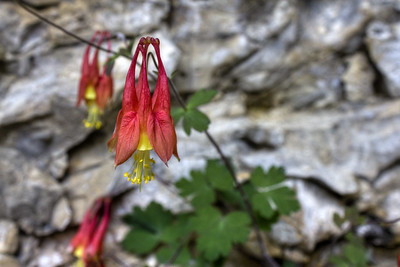
In the valley alongside Cane Creek one can find abundant flowering patches of phacelia, phlox, and trilliums. Along the rocky ledges and cliffs watch for bright red flowers of columbine. In a few places you'll also see usnea clinging to dead trees and be reminded of Spanish moss.


Geology
Cliffs of Fort Payne Limestone atop steep slopes of Chattanooga Shale are the obvious geology throughout the park. The base of the valleys is Catheys-Leipers Limestone, but doesn't play a large roll in the story that one sees at the Window Cliffs.

In the above recreation of a map made by Hugh Mills, Larry Knox and students in 1984, one can see the distribution of the more brittle silicastone Fort Payne facies that is partially responsible for the arch formation.
Geomorphology
Natural Arches
The silicastone Fort Payne is topped a less brittle facies of limestone along the knife's edge ridge of where the arches are located. This "roof" allows for the brittle Fort Payne to weather away underneith, while still being in place. As the brittle Fort Payne receeds, it leave gaps with roofs, or natural arches.

The recession process is driven at least partially by the oxbow bend of Cane Creek some 80' below the cliffs and arches. The stream carries away sediment, which is replaced from above as slopes gently give way to time, or by the occasional flood and slope failure. As the angle of repose reaches its maximum more sediment is carried away, and more material from above replaces it.


Waterfalls


Other, nearby waterfalls are also formed at the Fort Payne and Chattanooga Shale contact. However, Oxbow Falls, pictured right is formed at a steep portion of the Fort Payne on an unnamed tributary of Cane Creek. It's an unusual area, but worth wandering off trail to see.
Further Resources
The Land Trust for Tennessee
Official
Burgess Falls State Park - Management
Google Map
Tennessee Landforms


Comments