Fort Payne Formation & Chattanooga Shale Contact Waterfalls
Part of the beauty of the Eastern Highland Rim is that the morphology of landforms is largely consistent along its north-south axis. Waterfalls are especially predictable when one knows some basic geology, and can recognize the patterns.
It's hard to talk about waterfalls in Tennessee without mentioning the webpage Tennessee Landforms. Tom Dunigan has invested a lot of time in cataloging the resources of the state and making them available to outdoor enthusiasts. The existing waterfall data used in this post all originates from his webpage and my own exploration.
The map below illustrates the relationship to known waterfalls and to the contact between geologic units. Note that described waterfalls are found where streams cross the Fort Payne formation and (since there is no Chattanooga shale on this map, we'll use the next lower strata...) Leipers-Catheys limestone.
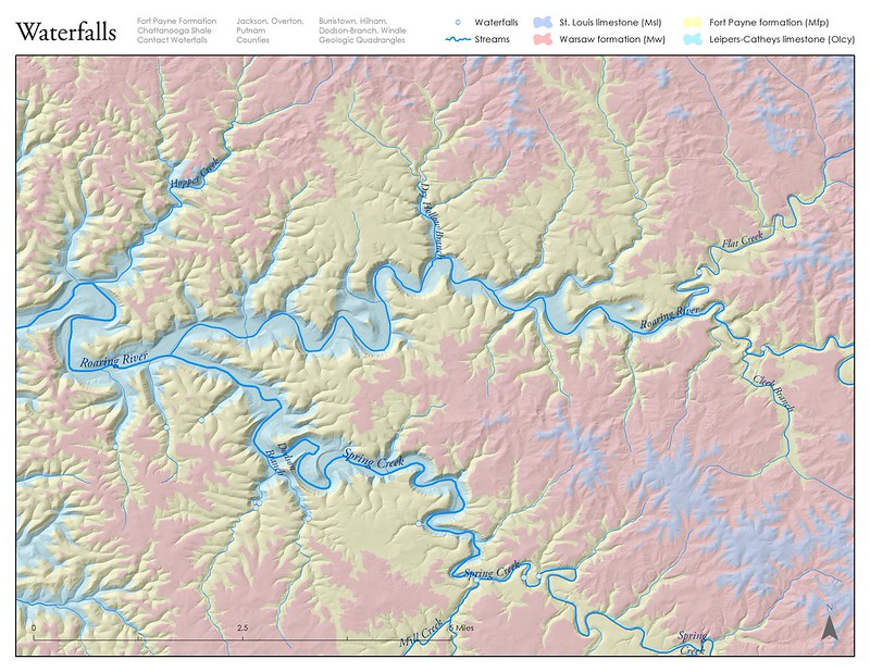
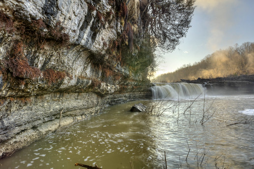
Examples of its waterfalls on this geologic contact include Cummins, Burgess, Twin, and many of the other large waterfalls in the region. Some areas produce large, spectacular waterfalls with deep plunge pools surrounded by an amphitheater of rocks. Some of them produce gentle cascades in steep walled valleys covered in wildflowers.
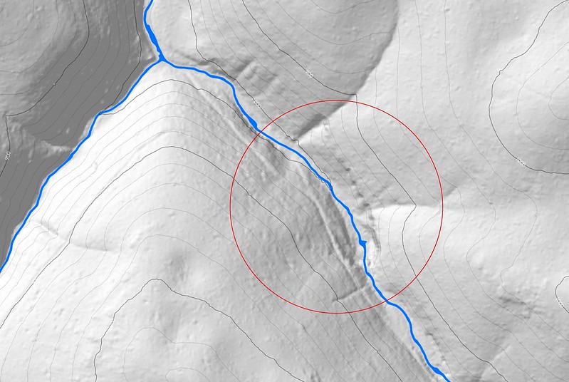
The ability to recognize both the Fort Payne formation and Chattanooga shale in the field is important for me in finding waterfalls. It's also important to be able to read maps and understand the shapes, forms, and signatures of each of these rocks to investigate leads.
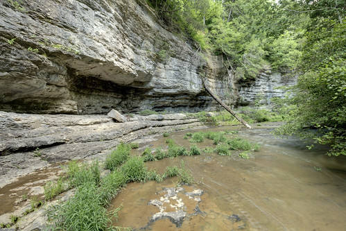
In the lidar map below, circled in red is an example of the signature I'm talking about. The south by southeast trending "U" shape indicates cliff lines. Where streams cross cliffs, one gets waterfalls. Knowing the general geology from being there in person tells me that it is Fort Payne formation and Chattanooga shale.
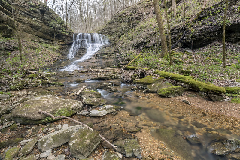
The above feature in map, presented below as it appears in real life.
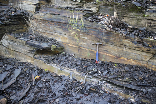
Spotting the Fort Payne formation in the field is first a matter of understanding what cherty limestone looks like. Chert has sharp edges. Because it is comprised of a lot of chert, it is not easily mechanically weathered and makes great cliffs. Fort Payne formation ranges in color from orange (gravels are often orange) to grey and one can find quartz geodes embedded in and scattered around it under cliff lines. The fossil crinoid stems are some of the largest in the region, with many as thick as a thumb. Other fossil evidence in it includes gigantic worm burrows, which appear as large linear features protruding from the bedrock. Finally, if you have a hand sample, remember that chert will scratch a knife's blade.
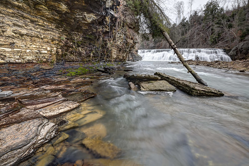
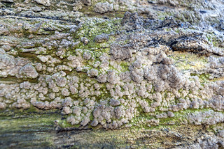
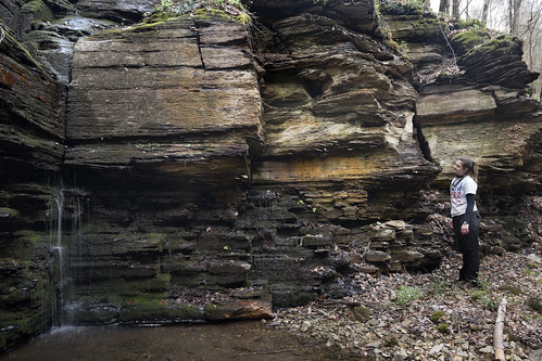
Chattanooga shale is much easier to identify. It is a thinly laminated black shale that will easily break given any mechanical weathering. It's ability to be easily mechanically weathered makes it easy to break with your bare hands. In the photograph of Waterloo falls below, the shale on the left appears white due to a gypsym crust (also see the close up of another example of gypsum crust on Chattanooga shale). If you're using color to identify the rock, be sure to look at a fresh face, as opposed to one which has mineralization on it. Often it will create large square or rectangular blocks due to vertical fractures which run at 90 degrees to one another. This can be seen in the photo below with Toni.
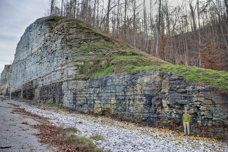
Below is a rock cut on Highway 52 in Clay County which exposes the Fort Payne formation and Chattanooga shale in a nice clean exposure. In a natural setting one will not have such a good view of the rock as it will be covered in soil, vegetation, and weathered faces which alter the color of the rock.
Below is Twin Falls at Rock Island State Park. This is likely the largest volume waterfall in the state of Tennessee. It originates from the overflow of the Collins River on the other side of the ridge as it passes through caves formed at upper contact of the Fort Payne formation with the Warsaw limestone. It cascades down more than 100 feet down into the Caney Fork river gorge.
It's hard to talk about waterfalls in Tennessee without mentioning the webpage Tennessee Landforms. Tom Dunigan has invested a lot of time in cataloging the resources of the state and making them available to outdoor enthusiasts. The existing waterfall data used in this post all originates from his webpage and my own exploration.
The map below illustrates the relationship to known waterfalls and to the contact between geologic units. Note that described waterfalls are found where streams cross the Fort Payne formation and (since there is no Chattanooga shale on this map, we'll use the next lower strata...) Leipers-Catheys limestone.
Examples of its waterfalls on this geologic contact include Cummins, Burgess, Twin, and many of the other large waterfalls in the region. Some areas produce large, spectacular waterfalls with deep plunge pools surrounded by an amphitheater of rocks. Some of them produce gentle cascades in steep walled valleys covered in wildflowers.
The ability to recognize both the Fort Payne formation and Chattanooga shale in the field is important for me in finding waterfalls. It's also important to be able to read maps and understand the shapes, forms, and signatures of each of these rocks to investigate leads.
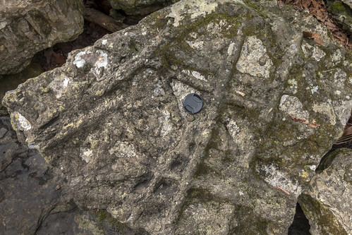
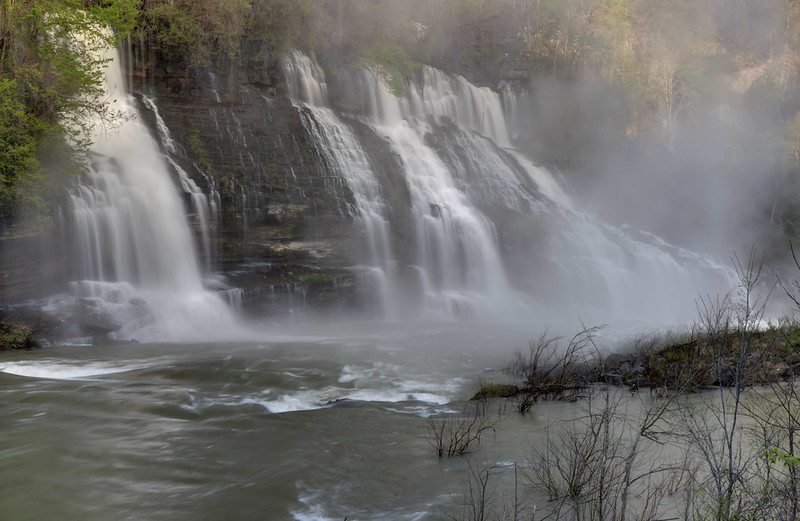
In the lidar map below, circled in red is an example of the signature I'm talking about. The south by southeast trending "U" shape indicates cliff lines. Where streams cross cliffs, one gets waterfalls. Knowing the general geology from being there in person tells me that it is Fort Payne formation and Chattanooga shale.

The above feature in map, presented below as it appears in real life.
Spotting the Fort Payne formation in the field is first a matter of understanding what cherty limestone looks like. Chert has sharp edges. Because it is comprised of a lot of chert, it is not easily mechanically weathered and makes great cliffs. Fort Payne formation ranges in color from orange (gravels are often orange) to grey and one can find quartz geodes embedded in and scattered around it under cliff lines. The fossil crinoid stems are some of the largest in the region, with many as thick as a thumb. Other fossil evidence in it includes gigantic worm burrows, which appear as large linear features protruding from the bedrock. Finally, if you have a hand sample, remember that chert will scratch a knife's blade.
Chattanooga shale is much easier to identify. It is a thinly laminated black shale that will easily break given any mechanical weathering. It's ability to be easily mechanically weathered makes it easy to break with your bare hands. In the photograph of Waterloo falls below, the shale on the left appears white due to a gypsym crust (also see the close up of another example of gypsum crust on Chattanooga shale). If you're using color to identify the rock, be sure to look at a fresh face, as opposed to one which has mineralization on it. Often it will create large square or rectangular blocks due to vertical fractures which run at 90 degrees to one another. This can be seen in the photo below with Toni.
Below is a rock cut on Highway 52 in Clay County which exposes the Fort Payne formation and Chattanooga shale in a nice clean exposure. In a natural setting one will not have such a good view of the rock as it will be covered in soil, vegetation, and weathered faces which alter the color of the rock.
Below is Twin Falls at Rock Island State Park. This is likely the largest volume waterfall in the state of Tennessee. It originates from the overflow of the Collins River on the other side of the ridge as it passes through caves formed at upper contact of the Fort Payne formation with the Warsaw limestone. It cascades down more than 100 feet down into the Caney Fork river gorge.


Comments