KTAG - Cave Density Map
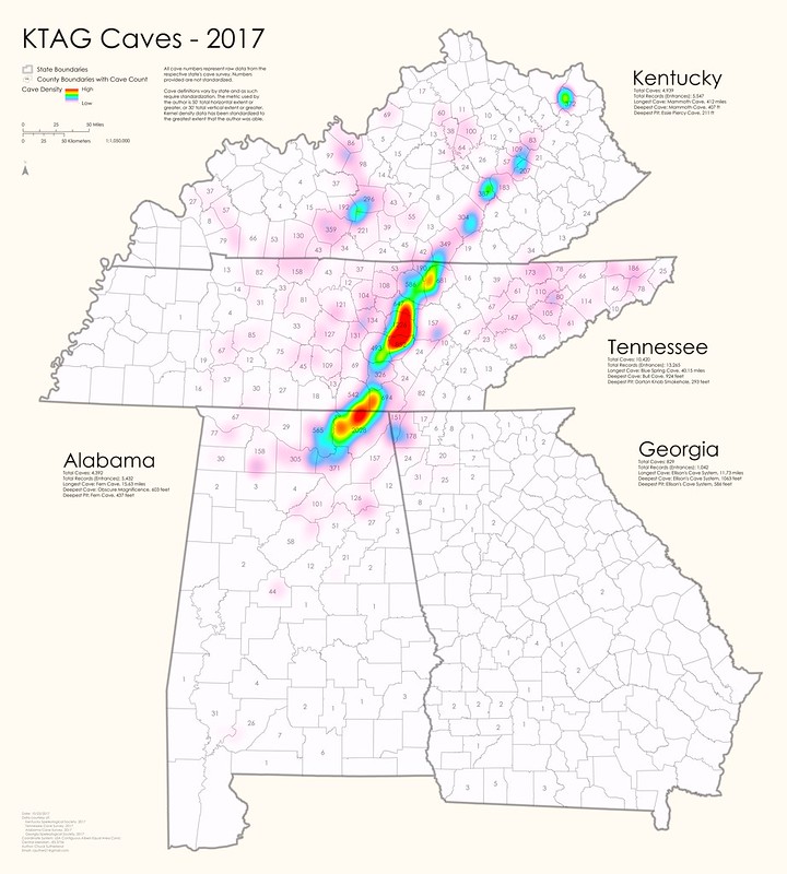
This is a map showing the density and distribution of caves in Kentucky, Tennessee, Alabama, and Georgia (KTAG). The strong line of density extending north-east from the intersection of Tennessee, Alabama, and Georgia shows the western escarpment of the Cumberland Plateau where Mississippian aged limestones outcrop and are exposed to weathering processes.
At the southern end of the Cumberland Plateau it becomes more heavily dissected, with islands of Plateau present amidst the Highland Rim. Along the margins of these islands caves can be exposed, which explains the dispersion at the southern extent of the Plateau.
Central and Western Kentucky show a secondary area of cave density; a ring of Mississippian aged carbonates has been exposed from the weathering of the Cincinnati Arch. Mammoth Cave resides in the densest part of this region.
This map was created using data from the following sources:
- Alabama Cave Survey (ACS)
- Georgia Speleological Society (GSS)
- Kentucky Speleological Society (KSS)
- Tennessee Cave Survey (TCS)
ArcMap 10.3 by ESRI was used to create the map. Workflow follows.
· For Tennessee, Alabama, and Georgia
- Tabular data joins in Access, output to Excel table
- Format Excel tables by converted DMS to DD
- Reference E1 (only one entrance per cave; the first documented entrance) points
- Spatially join points to county feature class and display count as label
- Kernel Density
· For Kentucky
- Summarize county table and tabular join to county feature class and display count as label
- Summarize 7.5' quadrangle table and tabular join to 7.5' quadrangle feature class
- Feature to point (create centroid) of quadrangle feature class; preserve count attribute
- Kernel density with new quad centroid feature class with count as Z attribute
cave, location, density, distribution, records, cave location, cave density, cave distribution, cave records, National Speleological Society, NSS, Alabama Cave Survey, ACS, Georgia Speleological Society, GSS, Kentucky Speleological Society, KSS ,Tennessee Cave Survey ,TCS, Kentucky, Tennessee, Alabama, Georgia, KY, TN, AL, GA, KTAG ,TAG, ArcMap ,ESRI, Spatial Analyst, cartography, map, analysis, heat map, Geographic Information Systems, GIS, Southern Sandstone Ridges, Southern Dissected Ridges and Knobs, Southern Shale Valleys, Limestone Valleys and Coves, Cumberland Plateau, Plateau Escarpment, Southern Limestone/Dolomite Valleys and Low Rolling Hills, Buhrstone/Lime Hills, Coastal Plain Red Uplands, Dougherty Plain, Southeastern Floodplains and Low Terraces, Southern Hilly Gulf Coastal Plain, Southern Sedimentary Ridges, Southern Table Plateaus, Southern Pine Plains and Hills, Atlantic Southern Loam Plains, Carter Hills, Caseyville Hills, Crawford-Mammoth Cave Uplands, Cumberland Mountain Thrust Block, Dissected Appalachian Plateau, Dissected Plateau, Eastern Highland Rim, Fall Line Hills, Green River-Southern Wabash Lowlands, Hills of the Bluegrass, Inner Bluegrass, Inner Nashville Basin, Knobs-Lower Scioto Dissected Plateau, Knobs-Norman Upland, Little Mountain, Mitchell Plain, Northern Forested Plateau Escarpment, Northern Hilly Gulf Coastal Plain, Ohio/Kentucky Carboniferous Plateau, Outer Bluegrass, Outer Nashville Basin, Sequatchie Valley, Shale Hills, Southern Crystalline Ridges and Mountains, Southern Inner Piedmont, Southern Metasedimentary Mountains, Southern Outer Piedmont, Talladega Upland, Tallahasee Hills/Valdosta Limesink, Tifton Upland, Transition Hills, Western Highland Rim, Western Pennyroyal Karst Plain


Comments