Inspection of Tornado Damage using Satellite Imagery
March 3rd, 2020 a deadly tornado touched down in Putnam County, Tennessee. It's 8.2 mile path destroyed more than 100 homes and left a normally happy community heartbroken and distraught. A week on, this is an analysis of what happened using GIS data and aerial imagery.
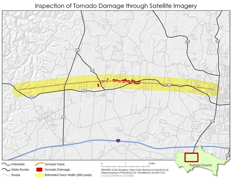
How do we get to the above map? The track was provided by National Weather Service (NWS). The track buffer was made using attribute data provided by NWS.
NWS update for Putnam County Tornado
Regions affected: Putnam County, City of Baxter, City of Cookeville
Max Rating: EF-4
Max Winds: 175 mph
Path Length: 8.2 miles
Path Width: 500 yards
Time on the ground: 8 min
Forward speed: 65 mph
Buildings destroyed: 100
Road Crossings: 35
Affected Area (500 yard buffer of tornado path)
Buildings within affected area: 1,812
Landuse:
Survey summary:
A violent tornado tracked across western and central Putnam County, resulting in numerous destroyed homes, 30-35 of which were destroyed completely, and caused 88 injuries and 18 fatalities. The tornado began 2.5 miles northwest of Baxter where it produced EF-0 damage for 2.7 miles as it crossed Gainesboro Highway. The tornado intensified to EF-1 and EF-2 intensity in the Prosperity Pointe subdivision just north of us 70N/Nashville Highway and further intensified to EF-3 as it crossed Bloomington Road and Clemmons Road, severely damaging several homes. The tornado then became violent for 0.8 miles as it entered the area around McBroom Chapel Road, where it reached EF-4 intensity, completely destroyed over a dozen homes, and caused numerous fatalities with the heaviest damage concentrated on Hensley Drive. EF-4 damage continued eastward to Echo Valley Drive, where an apartment complex was completely destroyed. EF-2 and EF-3 damage continued eastward for 2.0 miles, affecting homes along us 70N/W Broad Street, before rapidly coming to an end near n Franklin Avenue just west of Cookeville Regional Medical Center.
How do we get to the above map? The track was provided by National Weather Service (NWS). The track buffer was made using attribute data provided by NWS.
NWS update for Putnam County Tornado
Regions affected: Putnam County, City of Baxter, City of Cookeville
Max Rating: EF-4
Max Winds: 175 mph
Path Length: 8.2 miles
Path Width: 500 yards
Time on the ground: 8 min
Forward speed: 65 mph
Buildings destroyed: 100
Road Crossings: 35
Affected Area (500 yard buffer of tornado path)
Buildings within affected area: 1,812
Landuse:
| Land use / Land cover | Acres | Percent |
| Agriculture | 1,220.34 | 38.78% |
| Commercial | 194.65 | 6.18% |
| Industrial | 56.76 | 1.80% |
| Public/Semi-Public Uses | 113.28 | 3.60% |
| Residential | 1,052.35 | 33.44% |
| Transportation | 226.80 | 7.21% |
| Vacant | 283.03 | 8.99% |
Survey summary:
A violent tornado tracked across western and central Putnam County, resulting in numerous destroyed homes, 30-35 of which were destroyed completely, and caused 88 injuries and 18 fatalities. The tornado began 2.5 miles northwest of Baxter where it produced EF-0 damage for 2.7 miles as it crossed Gainesboro Highway. The tornado intensified to EF-1 and EF-2 intensity in the Prosperity Pointe subdivision just north of us 70N/Nashville Highway and further intensified to EF-3 as it crossed Bloomington Road and Clemmons Road, severely damaging several homes. The tornado then became violent for 0.8 miles as it entered the area around McBroom Chapel Road, where it reached EF-4 intensity, completely destroyed over a dozen homes, and caused numerous fatalities with the heaviest damage concentrated on Hensley Drive. EF-4 damage continued eastward to Echo Valley Drive, where an apartment complex was completely destroyed. EF-2 and EF-3 damage continued eastward for 2.0 miles, affecting homes along us 70N/W Broad Street, before rapidly coming to an end near n Franklin Avenue just west of Cookeville Regional Medical Center.


Comments