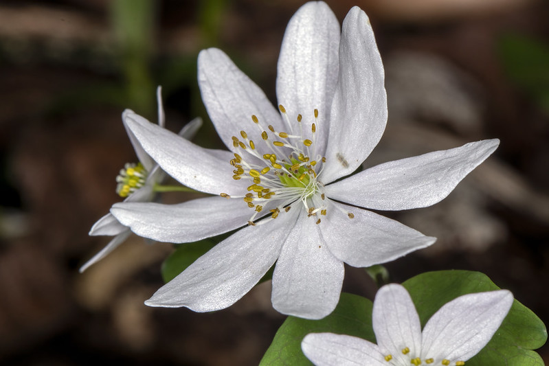
Every spring my photographic activity emerges from its winter slumber and I begin re-learning everything I once knew about wildflowers again. I love this time of year when I can start wearing shorts again, and see the familiar wildflowers return to our roadsides and hollers.

|
While I thoroughly enjoy capturing the beauty of wildflowers, I also like to think about how they ended up in their current location. As a practitioner of Geographic Information Systems (GIS), I find this question particularly intriguing. I provide this not as an empirical study, but rather a casual conversation to introduce readers to GIS concepts as related to wildflowers.
The locations where I find my favorite wildflowers share a few common traits: steep slopes facing different directions (known as "aspect" in GIS) and intermittent water sources resulting from nested water tables. By seeking out these characteristics, I am more likely to find ideal habitats for wildflowers.
|
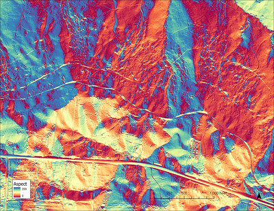
Using GIS, I can easily develop "layers" of data that illustrate these and other landscape qualities. Between taking photographs, I often contemplate how the landscape would appear in ArcGIS Pro, the software I use to analyze these attributes. Here, I've shared some of the products I've created that highlight attributes that influence wildflower habitats. While this is not an exhaustive list, it covers many of the significant variables.
|
Aspect, or the direction that a slope faces, plays a significant role in the habitat of the plants living there. It impacts the amount of sunlight the area receives, with south-facing slopes receiving the most sunlight in the Northern Hemisphere. Additionally, seasonal storms can disproportionately impact vegetation on southwest-facing slopes, leading to more damage to larger plants.
|
|
|
Elevation, while a minor player in most of Tennessee does have an impact on both temperature and rainfall. Higher elevations mean cooler temperatures and less rainfall broadly for most of Tennessee.
|

|
|
Slope is another crucial factor in habitat development, as it affects soil creation. Depending on the bedrock geology, high slopes may mean a rocky environment with minimal soil, or a thin layer of soil perched atop easily broken bedrock. Slope and aspect also impact the amount of solar radiation that reaches a given area.
|

|
|
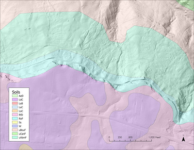
Soil characteristics are essential to habitat development. Factors such as soil acidity, drainage, organic content, and depth all influence which plants can thrive in a given area. Soil scientists have developed detailed maps that illustrate soil types and attributes for most of the United States.
|
|
|
Solar radiation refers to the amount of sunlight that falls on a specific unit of area (such as a square foot) over a given period of time. The map I've provided shows the impact of solar radiation in the spring, with significantly more sunlight in the summer. Canopy cover also affects the amount of sunlight reaching the ground, with well-developed forests providing less light to the understory below.
|

|
While most geologic maps are at a scale too large to provide any meaningful data to a wildflower enthusiast, geology is a huge driver in habitat development. Intermittant aquitards (rocks that do not let water penetrate lower into the Earth) create nested water tables changing locally how moist the soil is and where flora and fauna can access water. Karst environments also move water in less predictable ways than simply having water flow in a surface stream. In karst, sinkholes and springs are huge drivers of habitat diversity with both providing cooler and less windy environments than surrounding areas.


Comments